Introduction
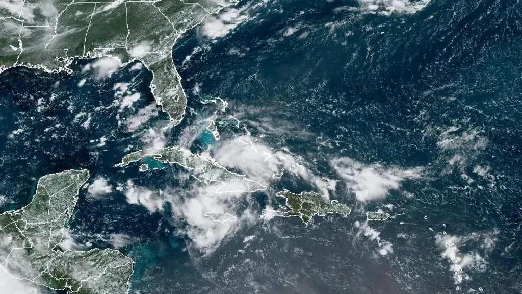
A significant weather event is unfolding as a cluster of storms moves from Cuba toward the coast of Florida, bringing with it an alarming forecast of heavy rainfall and potential flooding. This developing situation has prompted Governor Ron DeSantis to declare a state of emergency in over 50 counties across the state. The National Hurricane Center (NHC) has issued warnings and watches, preparing residents for the impact of this severe weather event.
The Storm’s Current Status
Formation and Trajectory
As of late Friday morning, the storm system, currently forming over Cuba, is approximately 420 miles (675 kilometers) from Key West, Florida. Forecasters at the National Hurricane Center report that the system is slowly organizing and could significantly impact the west coast of Florida as early as Saturday night. The storm’s trajectory suggests a potential landfall anywhere between Apalachicola and the Tampa Bay area, with the most critical period expected to be late Sunday into early Monday.
Expected Impact
Forecasters anticipate that the storm will bring intense rainfall, with up to 12 inches of rain expected across various parts of Florida. This heavy precipitation could lead to both flash flooding and prolonged urban flooding in several areas. The National Hurricane Center has cautioned that while some areas may experience isolated river flooding, the primary concern is the potential for extensive flash and urban flooding.
Regional Warnings and Precautions
Tropical Storm Warning and Watch
In response to the approaching storm, a tropical storm warning has been issued for several regions along the southwest coast of Florida. Areas from East Cape Sable to Bonita Beach are particularly at risk of experiencing high wind gusts and substantial rainfall. Additionally, parts of the southern and western coasts, including the Florida Keys, are under a tropical storm watch, indicating that storm conditions could begin to affect these areas within the next 48 hours.
Potential Flooding and Storm Surge
The National Hurricane Center has highlighted the possibility of storm surges reaching one to three feet in areas such as Aripeka, Card Sound Bridge, Tampa Bay, and Charlotte Harbour. These surges, combined with the expected heavy rainfall, could exacerbate flooding conditions, particularly in low-lying regions.
State of Emergency and Local Preparedness
Governor’s Declaration
Governor Ron DeSantis has declared a state of emergency for more than 50 counties in Florida, including Orange County, which is home to over 1.4 million residents and major attractions like Walt Disney World and Universal Studios. This declaration allows for the mobilization of resources and personnel to address the potential impacts of the storm.
Infrastructure and Public Services
Governor DeSantis has warned that the storm could cause significant damage to infrastructure, including major interstates, roadways, bridges, airports, schools, hospitals, and power grids. He emphasized that the storm’s impact could lead to widespread power outages and significant disruptions to daily life. The governor noted that water tables in some areas are already saturated, which could exacerbate flooding issues.
Broader Context: Hurricane Season and Previous Storms
Hurricane Season Outlook
The current storm is occurring amid a hurricane season that is projected to be particularly active. According to the National Oceanic and Atmospheric Administration (NOAA), the North Atlantic could experience up to seven major hurricanes of Category 3 strength or higher this year. This forecast suggests a significantly heightened risk compared to the average hurricane season.
Recent Storms
So far this year, the Atlantic has seen three named storms: Alberto, Beryl, and Chris. Hurricane Alberto resulted in at least four fatalities, while Hurricane Beryl caused over 60 deaths, including 36 in the Houston, Texas area. These events highlight the severity and potential impact of hurricanes and tropical storms during the current season.
Conclusion
As Florida prepares for the arrival of this storm system, residents and officials alike are bracing for what could be a challenging period of heavy rain and flooding. With significant rainfall expected and the possibility of widespread flooding and infrastructure damage, it is crucial for those in affected areas to stay informed and prepared. The state’s emergency measures and the ongoing monitoring of the storm’s progress will be vital in managing the impact of this severe weather event.
For further information on this developing story, please check the original source here.
For continuous updates on storm conditions and other significant weather events, visit our US & Canada section here.


